
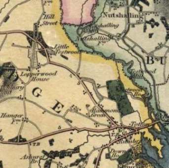
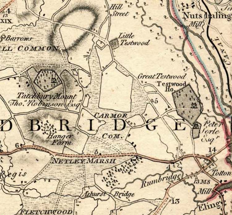
On the Right is part of Greenwoods 1826 Map Calmore is Not marked on this Map, But it is the area in the field by the Letters G E ,The Black Line is the Southampton Andover Canal not the Railway line it goes Via Millbrook Redbridge Romsey and Timsbury An exhibition of the History of Calmore will be held in the Community Centre during Calmore Show on 20th of July 2002
Calmore - what does the name mean? Most old names are descriptive and Calmore is not an exception. When the name was looked up it was found to mean "Cabbages on the marsh" or in other words the marsh or moor where cabbages grow. These cabbage plants would've been Sea Kale, hence the name Kalmoor - Calmoor - Calmore, its only in modern times that there has been any consistency in spellings.
The area of low land surrounding Tatchbury Mount was extremely boggy and only suitable for farming in the drier months of the year. In the Napoleonic era the Calmore canal was dug to drain the Netley Marsh area. The land use changed, more farms and different crops; as the land became drier. One of the new crops were flowers and several nurseries were in the area. The next big change came 150 years later with the construction of the estate. This is only our recent history, we know that the history of Calmore goes back a long way, there is evidence of prehistoric land use.
In prehistoric times the people who lived on the higher and drier land in the area built field enclosures on the lower wetter areas. Evidence of these fields still survive, they were fenced with banks to protect· their animals. Wooden structures would have rotted in the wet ground and the wood was also needed for fuel and the construction of their homes. The use of banks therefore made a lot of sense as well as making a dry walkway among the fields. Have you guessed where they are? The banks can be seen on 2 sides of the playing fields in the centre of the estate, sadly they are now becoming eroded.
During the Iron Age a hill fort was built at Tatchbury Mount, consisting of extensive earthworks and defences, high banks with wooden fences around the buildings. The earthworks were an a grand scale and extended over 5 acres, you can still see them today.
We know the Romans were in the area due to the remains of several roads and other finds in the New Forest and Southampton, one of their roads is just to the north of Calmore.
Later the Saxons invaded our shore via Southampton Water, a huge battle took place at "Netley Marsh" the area around Tatchbury (which includes Calmore). In excess of 5000 people were slain including the local King whose stronghold was the hill fort. The Saxon invaders were the forebears of King Alfred the Great.
In later years as our community grew we have had some unusual trades - Boat Building, Laundry, Glove making and Lace making as well as the trades and jobs that went hand in hand with the landed gentry and farming. The laundry was done in the Calmore pond (site of the Saxon Pub); the owner of loperwood Manor planted a belt of trees in Calmore Road to obscure the washing line. The gloves made were of such a high quality that the Royal family purchased them. Although you might think it peculiar for a boat builder to have his business inland not only did it show up in the 1881 censes but I can remember another firm in the 1960' s.
We also have a tradition of community shows like the Calmore Show today, the village held Peace celebration shows after both World Wars. Calmore residents were founder members of The New Forest Show, which in its early days was held at both Bartley Cross and at Totton. Another tradition, which is continuing today, is our community halls, both the old village hall in Pauletts Lane and the Calmore Community Centre were originally funded by subscription, each family at the time of construction contributing £1 towards the cost.
But to bring us full circle and back to cabbages and ....? No not kings but caterpillars. The pre-school playgroup at Pauletts Lane moved out of the old village hall and into the infant school so it needed a new name, the name they chose was Caterpillars. I thought this was very apt seeing that caterpillars eat cabbages and their playgroup is in middle of an ancient cabbage patch.
An exhibition of the History of Calmore will be held in the Community Centre during Calmore Show on 20th of July 2002
If you have any information on our local history please get in touch on Tel :023 8086 5997.
Or E/Mial Calmore Show
In the Totton & Eling Heritage Centre you can take a walk through time from the Bronze age to the present day. The Centre also houses the Bronze Age dagger found to the north of the Town when the new Testwood Lakes were being excavated. After your visit why not have a coffee or a light snack in our adjoining Cafe. The Centre is open in Summer from Wednesday to Sunday 10.00 a.m. to 4.00 p.m. and from November to Easter 10.00 a.m. to 4.00 p.m. on weekends only.
Further details can be obtained by Telephoning 023 8066 6339
Also Look at the Coming New Waterside Heritage Centre
Eling Tide Mill was restored in 1980 as a working Tide Mill Museum. It is one of the few surviving tide mills in the world to harness the power of tide for the regular Production of flour. The earliest record of a Mill on Eling causeway is 1086 but the present building dates from the 18th Century.Eling Tide Mill is not able to operate at high tides
For details of milling and opening times you can Telephone 023 8086 9575.
Totton & Eling current population is about 28,000 and is situated in the New Forest District and County of Hampshire. Situated on the River Test, the area has a long history of shipbuilding but also maintains strong links with the Forest. Until the 1950's New Forest ponies used to roam freely around the town.
Totton Rivers are The Test, Blackwater, Bartley Water and the Rum which is not marked on many maps today but explains Rumbridge street.
In 1974 Eling Parish Council became Totton & Eling Town Council due to the increase in size of Totton town. In 850ad the West Saxon King Aethelfulf gave land for a burial ground and church at Eling Hill. The church built on the site in the 9th Century was replaced with a simple stone church by the Normans and part of this original building can still be seen today.
Eling was entered in the doomsday book as Edlinges and Totton as Totintone. And a Mill which is also in the survey still survives today as the Eling Tide Mill. The History of this area can be followed at the Totton & Eling Heritage Centre which takes you back to the Bronze Age when some people lived just north of the town at what is now Testwood lakes.
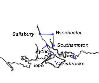 |
Romans In 55 BC Julius Caesar first Attacked Britain in 54 BC he came and conquered a large area of the country and sacked St Albans Imposed a tribute and left .Ninety years later in 43 AD Aulus Plautius a General of The Emperor Claudius Conquered Vectis (Isle of Wight) and subdued all the land between the Wash and the Southampton Water There are Remains of a Roman road from Nursling to Stony cross and roads from Winchester to Southampton and from Lepe to Hythe .It is thought that the Romans used a ferry from hythe to Southampton and a ferry from Lepe to the Isle of Wight, Their are remains of roman pottery works in the New Forest. |
 |
Saxon England The Jutes were The First Tribe to
settle in England so called because they came from Jutland , Hengist &
Horsa were the first in 449 AD, they founded the Kingdom of Kent. But it
was in 495 AD that Cerdic and his son Cynric landed in southampton water
and later went on to Take Winchester and the Isle of Wight they founded
the Kingdom of Wessex. In 508 AD King Natanlaod was killed by Cerdic at
the Battle of Netley (Natanleag) .It is believed that the battle took
place at Netley Marsh .When over 5000 people were Killed. As you can see
from the maps the Coast Line was different in Roman & Saxon Times
and erosion has Changed the shape of the land. A.D. 679. The monastery of Coldingiham was destroyed by fire from heaven. A.D. 744. The stars went swiftly shooting; |
 |
St. Boniface (WINFRID, WYNFRITH).Apostle of Germany, martyred 5 June, 755 (754); He was a native of England, Abbey of Nhutscelle (Nutshalling) Nursling between Winchester and Southampton. Here, leading an austere and studious life under Abbot Winbert, In 716 he set out for the mission in Friesland. In the 12th century Simeon of Durham states that in 764 AD a number of places were devastated by fire: `The calamity struck Stretburg [Cirencester?], Winchester, Southampton, the city of London, the city of York, Doncaster and many other places.We now know that Southampton , Ipswich and London were all important trading centres, or wics, from the early 700s. All lay within Mercia, whose power in the 8th century covered the whole of England south of the Humber. |
 |
King Canute had his feet washed by the Sea
at southampton, when he proved to his lords that no man Ruled the waves
and such matters should be left for God. In the last 800 years the two
prominences at Lepe have disappeared. The Bays may have Silted up or the
prominences may have washed away or a combination of both but the Maps
of the land between the Isle of Wight and the Mainland changed
considerably |
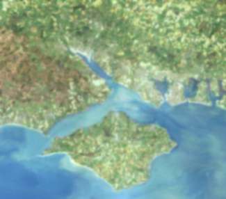 |
An Ariel Photo Shows Hampshire and the Isle of Wight as it Is Today |
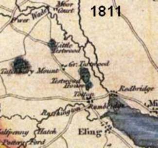 |
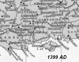
Early Maps were Mainly dependant on who wanted the map and for what purpose it was intended This 1811 Map is only a small portion of a Map Picturing the New Forest and so it is not as well detailed as Most Maps of the Area |
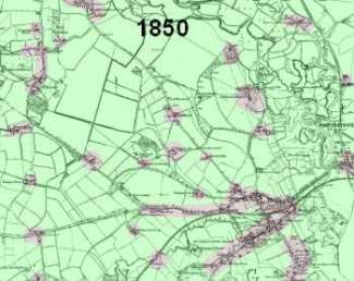 |
One Of the First Maps By the ordinance
Survey, Showing That Actual Buildings Were few and far Between. The Area
is mainly Farms with a few houses at Eling, Old Calmoor & Totton. In
Totton only Commercial Road, Rumbridge Street & Bears Lane had
Groups of houses. 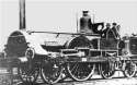 The Railway line had arrived in 1847 at Totton Via the Southampton to
Dorchester Line. The Locomotive "Frome" was used on The Line
The Railway line had arrived in 1847 at Totton Via the Southampton to
Dorchester Line. The Locomotive "Frome" was used on The Line |
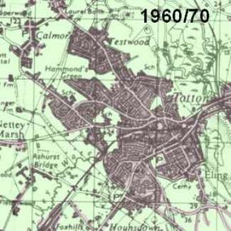 |
100 Years Later It Is easy to see how Totton has built up and all the Farms between The Roads are starting to fill up with Houses. Traffic Had become a nuisance in the Summer as Bottle necks at The World Stores at The Junction of Salisbury Road With the Ringwood Road (Now Totton Roundabout) Trying to pass from the New Forest In The West to Southampton in The East , and for a while Totton had the Record for the Longest Traffic Jam In The World. |
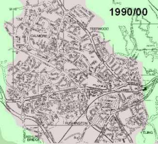 |
Totton and Eling is a town of nearly 28,000 population
in the New Forest District and is ideally situated for the New Forest,
the Coast and City Centre Shopping It has a Market every wednesday in
the Town Centre .A Heritage centre , a Working Tidal Mill, Football
Ground, Bowls Centre, And a number of Community Centres And Recreational
Facilities |
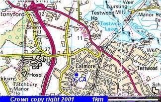 |
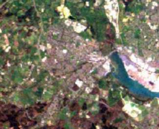
Image produced from the
Ordnance Survey Get-a-map
service. Image reproduced with kind permission of
Ordnance
Survey and Ordnance
Survey of Northern Ireland. The new Testwood Lakes at the top right of picture, where Recent Finds, include a Jetty dated to the Bronze Age ,and a Bronze Age dagger were found. The dagger is now in the Totton Heritage Centre, At Eling Quay. The Calmore community Centre is Marked CCA And Tatchbury hill fort is Just above Tatchbury Manor |
And it also shows the River Rum going from Calmore behind Testwood recreation Ground to Join Bartley Water at Brokenford Lane
65,000,000 Years Ago A Meteor struck the Earth at the northern tip of Mexico's Yucatan peninsula forming the Chicxlub crater. The size, direction, speed, and trajectory of the massive meteor created a tremendous fireball effect that swept across North America and quickly eradicated plant and animal life-forms, including the Dinosaur, across the continent. The debris released into the atmosphere by the collision subsequently caused a more gradual process of extinction across the rest of the globe.
Paleolithic 2,000,000 to 45,000 BC It Is Probable that Homus Erectus or Homo Sapiens. were in the area .Groups made brief halts beside a lake or slowly moving body of water. They made handaxes and other flint implements and used them to butcher the carcasses of horses or red deer they had either scavenged or hunted. Tools in the Paleolithic varied from finely made ovate handaxes, which were found to predate more crudely made triangular handaxes. This could be caused by the presence of different social groups with different technological traditions.
500,000 BC The Bytham River was the biggest river-system in Britain, It vanished during the Anglian Ice Age of 478-423,000 years ago. Britain at the time was attached to the continental European land-mass. The Presence of pre-Anglian occupation sites along the river sediments suggests it was the route into Britain from Europe. It would have been easy to walk along the river's sandy-gravelly banks, a ready water-supply, good vegetation and plenty of animals coming down to the water to drink.The river, which rose in the area near Birmingham and drained the Midlands for hundreds of thousands of years in the Early-Middle Pleistocene period, flowed eastwards from the west Midlands and Southern Pennines via Leicester and King's Lynn, then turned south. In the area around Bury St Edmunds, it turned east again towards Lowestoft and what is now the North Sea. Some parts of the river valley were obliterated by the Anglian ice-sheets, while others were covered and preserved by glacial deposits, The 14 sites where pre-Anglian artifacts have been found in Bytham River sediments include Waverley Wood near Coventry; and High Lodge, West Dereham, Feltwell, Brandon (Brick Kiln Farm), Hengrave, Lakenheath and Warren Hill in East Anglia.
Our second-largest river the Thames has no known pre-Anglian occupation sites.
45,000 to 35,000 BC Neanderthals Replaced by Modern Humans
10,000 BC End of Last Ice Age Altering The coastal regions Due to rising sea levels
6,500 BC The Flooding of the North sea Separating Britain from the Continent, Once a chalk belt covered from Flamborough Head to the Isle of Wight, but parts of it have been worn away and buried under loose clays and sands so forming the Hampshire Basin. Even today this is still happening the coastline and river banks being eroded away by the sea and the course of the rivers are altering. In earlier times when a river silted up or altered its course the people moved with it.
Southampton water and the estuary of the Test and Itchen Has a very long period of Tides due to the position of the Isle of Wight . The Tidal Wave coming up the English Channel enters First by The Solent and again Two hours Later By Spithead. Over The Centuries this has helped by the scouring of the Channel Between the Isle of Wight and England by the Tidal Action , And caused the silting up of the rivers because of the length of the Tide being held at bay allows a greater deposit of the silt. When one compares the old maps of southampton from when the Sea came up to the Old City Walls it is easy to see how fast in Time this can happen.
5000 BC Neolithic (new stone age) Period begins; first evidence of farming appears; stone axes, antler combs, pottery in common use.
4000 BC 6,000 years ago, Much of Britain was covered in forest. It was a major source of food and other materials for Mesolithic people. The late Mesolithic/early Neolithic forest was a kind of mosaic. Rather than being a homogenous mix of trees of different species, The forest on dryland consisted of stands of trees in which particular species were more common than others. While those in valleys (for instance in the Lake District), fringed with alder, birch and willow, with birch and open pools further out onto the floodplain. The Wildwood was not wholly composed of massive trunks just waiting to be cut down and incorporated into monuments. Large trees would have had to be selectively extracted from a large area. If prehistoric people cut down the smaller trees growing between the forest giants. Then by the end of the Neolithic there could have been areas where larger trees were more numerous than smaller ones, Such clearances would have produced irregular clearings. And if they cut and used the new growths in the clearings it could be the origin of some of our small irregular field systems. Construction of the "Sweet Track" (named for its discoverer, Ray Sweet) begun; many similar raised, wooden walkways were constructed at this time providing a way to traverse the low, boggy, swampy areas in the Somerset Levels, near Glastonbury; earliest-known camps or communities appear (ie. Hembury, Devon).
3500-3000 BC First appearance of long barrows and chambered tombs; at Hambledon Hill (Dorset),
People for the most part were hunters, But as they tamed Animals like the Dog, Horse , Goat, Sheep, Cow or Ox and Pigs. They Became more settled and began to grow corn, They could spin & Weave ,and began to make earthen Pots. But to do all this they had to settle to take advantage of their crops.
Rivers were used for Traveling and Trade as at this time as although they may have used pack animals. Traveling through the country on the tracks was both difficult and dangerous. As The Tribes were suspicious of people traveling through their territory
The first settlements would have been by the rivers to take advantage of the water, they would have required trees to be on hand for both fuel and hut building.Both Eling Hill Which had a Good View of Southampton Water , and TatchBury Hill Fort which had a good view of the rivers Test and Itchen and Their Basin would have been an ideal place to build as people changed from a hunter gathering life, to a Farming community . They are both on higher ground than the surrounding area and close enough to the water to allow easy access and travel. Totton would not be in existence yet and may have been started at the junction of tracks when in later years people wishing to cross from Southampton to Eling ,Salisbury, Romsey or Silchester had people waiting to cross the river and may have made a small trading place while waiting for the Tide or Ferry , If a Bridge had been built at the site of Totton before Roman or Saxon times then it seems unlikely that the Jetty found in Testwood lakes to the North of Totton. would have been built .
It can be assumed that the course and strength of the river was different then, Rivers were used for Traveling and Trade as at this time although they may have used pack animals traveling through the country on tracks (pack animals were used upto and including the early part of the the 19th century ) it was both difficult and dangerous. Sea and river travel generally allowed greater loads and quicker journeys. The Tribes were suspicious of people traveling through their territory and unless they new Them Their was a good chance of being attacked
2,500 BC Copper Age
2,300 BC Bronze Age
Comets & Meteors At least ten impact craters are known around the world dating from after the last Ice Age, and no fewer than seven of these date from around the 3rd millennium BC - although none occurred in the Near East. Air-explosions, however, can be more disastrous. A recent example - known as the Tunguska Event - occurred in 1908 over Siberia, when a bolide made of stone exploded about 5km above ground and completely devastated an area of some 2,000 km2 through fireball blasts. The bolide, although thought to have measured only 60m across, had an impact energy of about 40 megatons, Three times as great as the Arizona example and equivalent to the explosion of about 2,000 Hiroshima-size nuclear bombs, (The object that destroyed the dinosaurs, by contrast, is thought to have had a diameter of about 10km.) A smaller cometary blast occurred over the Brazilian rainforest in 1930.
2300 BC The Akkadian Empire in Mesopotamia, the Old Kingdom in Egypt, the Early Bronze Age societies in Israel, Anatolia and Greece, as well as the Indus Valley civilisation in India, the Hilmand civilization in Afghanistan and the Hongshan Culture in China - the first urban civilizations in the world - all fell into ruin at more or less the same time.
2350 BC Tree rings show disastrous growth conditions while sediment cores from lakes and rivers in Europe and Africa show a catastrophic drop in water levels. In Mesopotamia, vast areas of land appear to have been devastated, inundated, or totally burned.
It is now believed that these are natural Disasters , Brought about by Volcanos , Earth Quakes and Meteor & Comet strikes.
2,000 BC Metallurgy came relatively late to Britain, in the 4th millennium, Britain remained literally in the Stone Age. It would be a thousand years before the island was to experience metallurgy at all. But by 2000 BC the harder, tougher alloy of copper and tin known as bronze had also been invented. It replaced arsenical copper across Europe and dominated the European metals scene until the coming of iron more than 1,000 years later. In Britain, bronze was produced from the outset with an almost standard composition of 8 to 12 per cent tin, ensuring the optimum mix of qualities. The period also saw the appearance of beaker pottery in the British Isles. These highly distinctive vessels, often buried with the dead, were widespread in central Europe and Iberia before they were used in Ireland. Today, there is some reluctance to see the arrival of a new pottery form, as a sign of the arrival of a new population of immigrants. New artifacts and burial practices can, after all, simply reflect changing ideas or trade, which was well-established along the Atlantic seaboard in this period. But the idea of a Beaker Culture, with its distinctive pottery, funeral practices, flint arrows and established tradition of metal making, is hard to cast off.
1300 BC A large Bronze Age boat was discovered in Dover in 1992, dated to around 1300BC in the Middle Bronze Age made of four oak planks: two flat bottom planks and two curved side planks and additional side planks. The bottom planks were fixed together without nails or carpentry joints, but by ramming wedges and cross-timbers through a pair of upstanding ridges on either side of the main joint and through a series of cleats (or semi-circular wooden hoops). The Tools of the Time Wedges, axes, adzes, chisels and gouges would have been more than capable of producing good work.We know from other Bronze Age boats that carpentry jointing was known at the time.The side planks were stitched to the base by yew withies, and the seams made watertight by compressed moss. It seems, also, that the boat, some 15m long, was made out of single lengths of oak timber, requiring the use of massive trees with long, straight sections of trunk uninterrupted by branches. Boats did cross the channel in this period, part of the cargo of a Bronze Age boat - mainly broken metalwork - was found on the seabed off Dover in 1974. A scrap of unworked shale found in the boat has been proved to come from Kimmeridge Bay in Dorset, which may suggest the boat was plying along the south coast 3,000 years ago.
1200 BC, (see 2300 BC) Disaster and ruin overtook the Myceneans of Greece, the Hittites of Anatolia, the Egyptian New Kingdom, Late Bronze Age Israel, and the Shang Dynasty of China. Areas such as the Sahara, and around the Dead Sea, were once farmed but became deserts.
700 BC Iron Age
Animals of This Age which are no longer with us are Bears, Wolves, Beavers & Eagles
55 & 56 BC Caesar Came and attacked Britain Then Left
1 BC An Iron Age emporium flourished in the 1st century BC at Hengistbury Head in Dorset, Highsided flat bottomed trading vessels off-loaded heavy cargoes Quantities of wine amphorae from the Continent, and metal ores from Devon and Cornwall found at Hengistbury suggest that heavy cargoes were unloaded there, while evidence for large numbers of cattle, together with signs of butchery and leather-dressing, suggest that return cargoes may frequently have consisted largely of dry animal hides - a much lighter load requiring additional ballast. If they sailed light they would be unstable and liable to capsize, The 1st century BC/AD historian Strabo includes hides in his list of British exports, Ballast in antiquity was typically stone, sand, or gravel - gravel being most easily handled and moved about the ship, In Excavations hollows and scoops were found close to the old shore-line, where the flat-bottomed boats were beached while loading and unloading cargo‘s and enabling the shovelling of gravel directly on board.
43 AD The Romans Came to stay, Once they had established themselves they began the construction of a road system , Built by their army within a generation or two of their arrival. Built using a sophisticated surveying system, with gravel surfaces and bridges where necessary, the new road network represented a far-reaching modification to the landscape. Prior to the arrival of the Romans, there were no engineered roads in Britain - only trackways which followed the natural routes across the countryside. They also introduced regularly-planned towns. Hillforts, which served many purposes in Iron Age society, were largely abandoned, and their functions were taken over by new urban settlements, situated closer to water sources and the new road system. New building materials and Roman architectural styles were employed in the construction of shops, public buildings, and large private homes. Rural settlement patterns also changed in some areas, most notably in the development of the villa estate system. New plant varieties were introduced by the Romans, including rye, oats, vetch, and flax, as well as cabbage, parsnip, turnip, carrots and other vegetables, fruit trees such as the vine, plum, apple, mulberry, and walnut, and flowers such as the rose, violet, lily, pansy and poppy. And some historians say they introduced the rabbit ( some say the rabbit was introduced by the Normans who had special enclosures for them) They also introduced Cremation, lead mining operation in the Mendips, Pottery, Potter’s wheel bricks, tiles, shale and stone began to be used in addition to wattle and daub and timber. Improved farming tools such as a better plough and a winter and summer wheat crop, which had the effect of allowing a greater increase in the amount of livestock kept alive through the winter.
409 AD Romans left
449 AD Saxons Came
According to tradition, an important early king of Wessex was Cerdic. Cerdic settled in Wessex in the 490's and founded a royal house (family). Many later West Saxon kings, including Alfred the Great, claimed to belong to the House of Cerdic.
495 BC - Cerdic and Cynric, his son, land somewhere on the south coast, probably near the Hampshire-Dorset border. ( landed near Southampton Water and took Winchester and founded the Kingdom of Wessex ) He is said to have landed at lepe, Fawley and Ower But the coast line was different then and we will never be sure where he really landed and with the Finds of a jetty and bronze dagger at Testwood Lakes it is possible that the river was navigable upto and past Ower .It is said that the roman road from Nursling and Stony Cross took a turn this may have been because the river was easier crossed north of Ower . But as sediment has filled it in, what once may have been a navigable river has shrunk to what we Know today
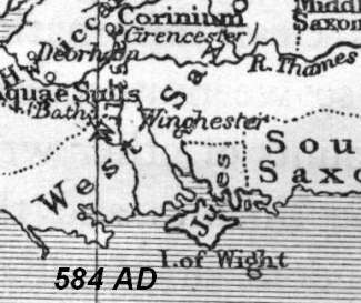
British Kingdoms probably existed in central southern Britain, the Saxon heartland. One possible King was Elaf(ius) the British leader whom St. Germanus met soon after his second landing in Britain in the 440s. He may have ruled the area round Caer Guinntguic (Roman venta) (Winchester, Hampshire). Another possible King, Nudd, may have been the King Natanlaod killed by Cerdic at the Battle of Netley (Natanleag) in AD 508.
One possible King of the area was Elaf(ius) the British leader whom St. Germanus met soon after his second landing in Britain in the 440s. He may have ruled the area round Caer Guinntguic (Winchester, Hampshire). Another possible King, Nudd, may have been the King Natanlaod killed by Cerdic at the Battle of Netley (Natanleag) in AD 508.
508 BC Cerdic begins to move inland and defeats British king Natanleod near present-day Southampton.
519 BC Kingdom of the West Saxons (Wessex) founded with Cerdic its first ruler.
534 BC Death of Cerdic. Cynric takes kingship.
Caer Celemion (Silchester, Hampshire) was certainly a centre for British resistance, as indicated by the protective dykes surrounding its northern borders. Legends of a giant named Onion living there, may indicate a King called Einion.
Winchester [Pre Roman Caer Guinntguic] ( Roman Venta ) and (Saxon ***)
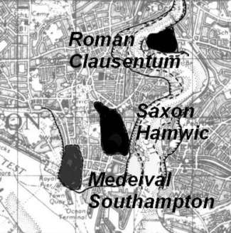
Southampton ( Roman Clausentum) ( Saxon Hamwic) Part of an exceptionally rich Anglo-Saxon cemetery has been excavated in the middle of Southampton one of Anglo-Saxon England's earliest towns. Graves were found furnished with weapons, gold and other fine jewelry. 7th century pottery and other artifacts from the site place the cemetery right at the start of Hamwic's existence, The dated objects bring the origin of the town into line with that of Lundenwic (London) and Ipswic (Ipswich), The excavation, directed by Roland Smith of Wessex Archaeology, took place on the site of Southampton Football Club's new stadium. Only the area under the stands was excavated, leaving the rest of the cemetery and other Anglo-Saxon remains undisturbed. The cemetery lay on the northeastern fringe of Hamwic, and the excavations also uncovered parts of the town. The relative shortage of solidly-made timber buildings and metalled streets - such as have been found elsewhere in Hamwic - suggest that this may have been a kind of shanty suburb of the Anglo-Saxon town.
Totton & Eling At one time the parish included Copythorne Calmore and Marchwood. Eling church has Saxon foundations, but is thirteenth century in its architecture. Near it is the eighteenth century tidal mill- restored by voluntary labour to working order. Life here can be traced from the Stone Age, through the Bronze Age to Roman times; Romano-British coins have been found at Houndsdown. The seventeenth century bridge over the Test which connected Eling with Southampton can still be seen. Today Totton forms most of the parish, and the old name relates only to a small part of it. Eling ,
Archaeological Sites and Remains In and About Totton & Eling
1. Tatchbury Mount Hill fort
2. Possible Roman Road (from Nursling To Stony Cross )
3. Mediaeval Site Lesteorde, now Testwood
4. St. Mary, Eling. (Site of old Saxon Church) Norman Church Built on old foundations Flint and stone structure. Aisles added early in C.13. Chancel rebuilt and south chapel added in C. 14. C. 1 5 tower. Nave and north aisle have old braced rafter roofs. C.18 mural monuments.
5. Manor House (Site)Colbury Manor. Originally given to the Abbot of Beaulieu. Confirmed by the King in 1317.
6. Manor House (Site) Langley Manor House. Mentioned in Domesday. No visible signs remain.
7. Testwood Lakes Site of Old Jetty and Bronze Dagger
Stone Age 'U' Flint Arrow and Spearheads Found in 1890 in Eling Recreation ground when it was Tamiands Gravel Pit. 'U' Flint Scraper Found in gravel pit. Now in Tudor House Museum. Paleolithic Flint Found in gravel pit. Hand Axe Found in spoil from construction of new round-about in 1969. Roman Urn and four coins of Posthumous and Gallienus. Found in 1814 at Houndsdown Hill. Stirrup and Chain Found at Colbury.
Their has been suggestions that Ower just north of Testwood lakes was the landing place of Cerdic in AD 495 But it is also said that he landed at Lepe Nr Calshot but most people do agree that his first landing was somewhere in Southampton waters.
Cerdices ora. Indications point to a site somewhere on the western shore of Southampton Water, near its head; and for reasons which will be evident later I should place Cerdices era at Totton. This is the natural haven of ships coming from the east, if they enter Southampton Water; there are no harbours between it and Calshot, and indeed Calshot is hardly a harbour at all. Totton is still used by quite big ships, and within living memory it was quite a busy port. It is at the head of Southampton Water, and they would naturally penetrate as far inland by water as they could. Another argument in its favour is the statement that the district between Cerdices era and Cerdices ford was called Natan leah. For immediately to the west of Totton is a low-lying district called Netley Marsh, and the early forms are consistent with a derivation from Natan leah.6 See Full Article Cerdic & The Cloven Way From an article by O.G.S. Crawford in Antiquity, Vol. V, December 1931.
From evidence now coming to light such as the finding of a wooden Jetty/Pier in Testwood lake it shows that the rivers were different in both position & depth and size in Prehistoric & Saxon Times . Their is evidence of a Roman road that Passes Just North of Calmore and south of Ower ( From Nursling to Stoney cross ). This was probably the road that led to the Roman pottery works in the new forest But later used by the Normans to travel from Winchester Via Nursling to their Hunting Lodges in the Forest
Lepe Being the Closest point To the Isle of White. Became an important Landing place for the Romans and later the Saxons . The Romans built a road which goes from lepe to Hythe . Their are no Remains found linking the Roman roads of Lepe/Hythe to Southampton/Winchester. But It may be that they had a ferry from Hythe to Southampton . In which case the only Roman Road In Totton & Eling Area would be the one mentioned earlier to the North of Calmore.
It is only in the last few centuries that the growth of the population of Totton has grown from a few houses on a meeting of roads to a village then a town.
700 BC St. Boniface (WINFRID, WYNFRITH). Apostle of Germany, date of birth unknown; martyred 5 June, 755 (754); emblems: the oak, axe, book, fox, scourge, fountain, raven, sword. He was a native of England, though some authorities have claimed him for Ireland or Scotland. The place of his birth is not known, though it was probably the south-western part of Wessex. Crediton (Kirton) in Devonshire is given by more modern authors. The same uncertainty exists in regard to the year of his birth. It seems, however, safe to say that he was not born before 672 or 675, or as late as 680. Descended from a noble family, from his earliest years he showed great ability and received a religious education. His parents intended him for secular pursuits, but, inspired with higher ideals by missionary monks who visited his home, Winfrid felt himself called to a religious state. After much difficulty he obtained his father's permission and went to the monastery of Adescancastre on the site of the present city of Exeter, where, under the direction of Abbot Wolfhard, he was trained in piety and learning. About seven years later he went to the Abbey of Nhutscelle (Nutshalling) Nursling between Winchester and Southampton. Here, leading an austere and studious life under Abbot Winbert, he rapidly advanced in sanctity and knowledge, excelling especially in the profound understanding of scriptures, of which he gives evidence in his letters. He was also well educated in history, grammar, rhetoric, and poetry. He made his profession as a member of the Benedictine Order and was placed in charge of the monastic school. At the age of thirty he was ordained priest. Through his abbot the fame of Winfrid's learning soon reached high civil and ecclesiastical circles. He also had great success as a preacher. With every prospect of a great career and the highest dignities in his own country, he had no desire for human glory, for the thought of bringing the light of the Gospel to his kindred, the Old Saxons, in Germany, had taken possession of his mind. After many requests Winfrid at last obtained the permission of his abbot. In 716 he set out for the mission in Friesland.
The next few articles show links between St Boniface & the Palatinate state & Daniel Defoe which could have changed The whole concept of The New Forest .
1. The site of Mainz (MAINZ, Germany. The capital of Rhineland-Palatinate state ) dates to a Celtic settlement where the Romans set up a military camp called Moguntiacum, after the Celtic god Mogo, in the 1st century BC. The town that grew around the camp became the capital of Germania Superior, but the Romans abandoned the area in the 5th century AD. A new town developed, and under St. Boniface in the 8th century it became the ecclesiastical center of Germany. After becoming a free city in 1244, Mainz grew in size and influence, gaining significance as a center of commerce, culture, and learning.
Mainz in Germany A link to City of Mainz Website
2. Louis XIV. His Third war (1689-97) was directed chiefly against Holland, whose stadholder had by then become King William III of England. The German province of the Palatinate was terribly wasted, but the Peace of Ryswick brought only slight gains for France. A French army under the command of Marshal Duras had invaded the Palatinate and some of the neighbouring principalities. But this expedition, though it had been completely successful, and though the skill and vigour with which it had been conducted had excited general admiration, could not perceptibly affect the event of the tremendous struggle which was approaching. France would soon be attacked on every side. It would be impossible for Duras long to retain possession of the provinces which he had surprised and overrun. An atrocious thought rose in the mind of Louvois, who, in military affairs, had the chief sway at Versailles. He was a man distinguished by zeal for what he thought the public interests, by capacity, and by knowledge of all that related to the administration of war, but of a savage and obdurate nature. If the cities of the Palatinate could not be retained, they might be destroyed. If the soil of the Palatinate was not to furnish supplies to the French, it might be so wasted that it would at least furnish no supplies to the Germans. The ironhearted statesman submitted his plan, probably with much management and with some disguise, to Lewis; and Lewis, in an evil hour for his fame, assented. Duras received orders to turn one of the fairest regions of Europe into a wilderness. Fifteen years earlier Turenne had ravaged part of that fine country. But the ravages committed by Turenne, though they have left a deep stain on his glory, were mere sport in comparison with the horrors of this second devastation. The French commander announced to near half a million of human beings that he granted them three days of grace, and that, within that time, they must shift for themselves. Soon the roads and fields, which then lay deep in snow, were blackened by innumerable multitudes of men, women, and children flying from their homes. Many died of cold and hunger: but enough survived to fill the streets of all the cities of Europe with lean and squalid beggars, who had once been thriving farmers and shopkeepers. Meanwhile the work of destruction began. The flames went up from every marketplace, every hamlet, every parish church, every country seat, within the devoted provinces. The fields where the corn had been sown were ploughed up. The orchards were hewn down. No promise of a harvest was left on the fertile plains near what had once been Frankenthal. Not a vine, not an almond tree, was to be seen on the slopes of the sunny hills round what had once been Heidelberg. No respect was shown to palaces, to temples, to monasteries, to infirmaries, to beautiful works of art, to monuments of the illustrious dead. The farfamed castle of the Elector Palatine was turned into a heap of ruins. The adjoining hospital was sacked. The provisions, the medicines, the pallets on which the sick lay were destroyed. The very stones of which Mannheim had been built were flung into the Rhine. The magnificent Cathedral of Spires perished, and with it the marble sepulchres of eight Caesars. The coffins were broken open. The ashes were scattered to the winds.William's attention was called to the wrongs which France had done to him and to his kingdom; and he was assured that, whenever he should resort to arms for the redress of those wrongs, he should be heartily supported by his people. He thanked the Commons warmly. Ambition, he said, should never induce him to draw the sword: but he had no choice: France had already attacked England; and it was necessary to exercise the right of selfdefence. A few days later war was proclaimed
In From London to Land's End by Daniel Defoe an article appears about The New Forest
3. A Proposal made a few years ago to the late Lord Treasurer Godolphin for re-peopling this forest, which for some reasons I can be more particular in than any man now left alive, because I had the honour to draw up the scheme and argue it before that noble lord and some others who were principally concerned at that time in bringing over--or, rather, providing for when they were come over--the poor inhabitants of the Palatinate, a thing in itself commendable, but, as it was managed, made scandalous to England and miserable to those poor people. Some persons being ordered by that noble lord above mentioned to consider of measures how the said poor people should be provided for, and whether they could be provided for or no without injury to the public, the answer was grounded upon this maxim--that the number of inhabitants is the wealth and strength of a kingdom, provided those inhabitants were such as by honest industry applied themselves to live by their labour, to whatsoever trades or employments they were brought up. In the next place, it was inquired what employments those poor people were brought up to. It was answered there were husbandmen and artificers of all sorts, upon which the proposal was as follows.
New Forest, in Hampshire, was singled out to be the place:- Here it was proposed to draw a great square line containing four thousand acres of land, marking out two large highways or roads through the centre, crossing both ways, so that there should be a thousand acres in each division, exclusive of the land contained in the said cross-roads. Then it was proposed to since out twenty men and their families, who should be recommended as honest industrious men, expert in, or at least capable of being instructed in husbandry, curing and cultivating of land, breeding and feeding cattle, and the like. To each of these should be parcelled out, in equal distributions, two hundred acres of this land, so that the whole four thousand acres should be fully distributed to the said twenty families, for which they should have no rent to pay, and be liable to no taxes but such as provided for their own sick or poor, repairing their own roads, and the like. This exemption from rent and taxes to continue for twenty years, and then to pay each 50 pounds a year to the queen-- that is to say, to the Crown.
To each of these families, whom I would now call farmers, it was proposed to advance 200 pounds in ready money as a stock to set them to work; to furnish them with cattle, horses, cows, hogs, &c.; and to hire and pay labourers to inclose, clear, and cure the land, which it would be supposed the first year would not be so much to their advantage as afterwards, allowing them timber out of the forest to build themselves houses and barns, sheds and offices, as they should have occasion; also for carts, waggons, ploughs, harrows, and the like necessary things: care to be taken that the men and their families went to work forthwith according to the design.
Thus twenty families would be immediately supplied and provided for, for there would be no doubt but these families, with so much land given them gratis, and so much money to work with, would live very well; but what would this do for the support of the rest, who were supposed to be, to every twenty farmers, forty or fifty families of other people (some of one trade, some of another), with women and children? To this it was answered that these twenty farmers would, by the consequence of their own settlements, provide for and employ such a proportion of others of their own people that, by thus providing for twenty families in a place, the whole number of Palatinates would have been provided for, had they been twenty thousand more in number than they were, and that without being any burden upon or injury to the people of England; on the contrary, they would have been an advantage and an addition of wealth and strength to the nation, and to the country in particular where they should be thus seated.
For example:- As soon as the land was marked out, the farmers put in possession of it, and the money given them, they should be obliged to go to work, in order to their settlement. Suppose it, then, to be in the spring of the year, when such work was most proper. First, all hands would be required to fence and part off the land, and clear it of the timber or bushes, or whatever else was upon it which required to be removed. The first thing, therefore, which the farmer would do would be to single out from the rest of their number every one three servants--that is to say, two men and a maid; less could not answer the preparations they would be obliged to make, and yet work hard themselves also. By the help of these they would, with good management, soon get so much of their land cured, fenced-off, ploughed, and sowed as should yield them a sufficiency of corn and kitchen stuff the very first year, both for horse-meat, hog-meat, food for the family, and some to carry to market, too, by which to bring in money to go farther on, as above. At the first entrance they were to have the tents allowed them to live in, which they then had from the Tower; but as soon as leisure and conveniences admitted, every farmer was obliged to begin to build him a farm-house, which he would do gradually, some and some, as he could spare time from his other works, and money from his little stock.
In order to furnish himself with carts, waggons, ploughs, harrows, wheel-barrows, hurdles, and all such necessary utensils of husbandry, there would be an absolute necessity of wheelwrights or cartwrights, one at least to each division. Thus, by the way, there would be employed three servants to each farmer, that makes sixty persons. Four families of wheelwrights, one to each division--which, suppose five in a family, makes twenty persons. Suppose four head- carpenters, with each three men; and as at first all would be building together, they would to every house building have at least one labourer. Four families of carpenters, five to each family, and three servants, is thirty-two persons; one labourer to each house building is twenty persons more. Thus here would be necessarily brought together in the very first of the work one hundred and thirty-two persons, besides the head- farmers, who at five also to each family are one hundred more; in all, two hundred and thirty-two.
For the necessary supply of these with provisions, clothes, household stuff, &c. (for all should be done among themselves), first, they must have at least four butchers with their families (twenty persons), four shoemakers with their families and each shoemaker two journeymen (for every trade would increase the number of customers to every trade). This is twenty-eight persons more. They would then require a hatmaker, a glover, at least two ropemakers, four tailors, three weavers of woollen and three weavers of linen, two basket-makers, two common brewers, ten or twelve shop-keepers to furnish chandlery and grocery wares, and as many for drapery and mercery, over and above what they could work. This makes two-and-forty families more, each at five in a family, which, is two hundred and ten persons; all the labouring part of these must have at least two servants (the brewers more), which I cast up at forty more. Add to these two ministers, one clerk, one sexton or grave-digger, with their families, two physicians, three apothecaries, two surgeons (less there could not be, only that for the beginning it might be said the physicians should be surgeons, and I take them so); this is forty-five persons, besides servants; so that, in short--to omit many tradesmen more who would be wanted among them-- there would necessarily and voluntarily follow to these twenty families of farmers at least six hundred more of their own people.
It is no difficult thing to show that the ready money of 4,000 pounds which the Government was to advance to those twenty farmers would employ and pay, and consequently subsist, all these numerous dependants in the works which must severally be done for them for the first year, after which the farmers would begin to receive their own money back again; for all these tradesmen must come to their own market to buy corn, flesh, milk, butter, cheese, bacon, &c., which after the first year the farmers, having no rent to pay, would have to spare sufficiently, and so take back their own money with advantage. I need not go on to mention how, by consequence provisions increasing and money circulating, this town should increase in a very little time. It was proposed also that for the encouragement of all the handicraftsmen and labouring poor who, either as servants or as labourers for day-work, assisted the farmers or other tradesmen, they should have every man three acres of ground given them, with leave to build cottages upon the same, the allotments to be upon the waste at the end of the cross-roads where they entered the town. In the centre of the square was laid out a circle of twelve acres of ground, to be cast into streets for inhabitants to build on as their ability would permit--all that would build to have ground gratis for twenty years, timber out of the forest, and convenient yards, gardens, and orchards allotted to every house. In the great streets near where they cross each other was to be built a handsome market-house, with a town-hall for parish or corporation business, doing justice and the like; also shambles; and in a handsome part of the ground mentioned to be laid out for streets, as near the centre as might be, was to be ground laid out for the building a church, which every man should either contribute to the building of in money, or give every tenth day of his time to assist in labouring at the building.
I have omitted many tradesmen who would be wanted here, and would find a good livelihood among their country-folks only to get accidental work as day-men or labourers (of which such a town would constantly employ many), as also poor women for assistance in families (such as midwives, nurses, &c.). Adjacent to the town was to be a certain quantity of common-land for the benefit of the cottages, that the poor might have a few sheep or cows, as their circumstances required; and this to be appointed at the several ends of the town. There was a calculation made of what increase there would be, both of wealth and people, in twenty years in this town; what a vast consumption of provisions they would cause, more than the four thousand acres of land given them would produce, by which consumption and increase so much advantage would accrue to the public stock, and so many subjects be added to the many thousands of Great Britain, who in the next age would be all true-born Englishmen, and forget both the language and nation from whence they came. And it was in order to this that two ministers were appointed, one of which should officiate in English and the other in High Dutch, and withal to have them obliged by a law to teach all their children both to speak, read, and write the English language. Upon their increase they would also want barbers and glaziers, painters also, and plumbers; a windmill or two, and the millers and their families; a fulling-mill and a cloth-worker; as also a master clothier or two for making a manufacture among them for their own wear, and for employing the women and children; a dyer or two for dyeing their manufactures; and, which above all is not to be omitted, four families at least of smiths, with every one two servants--considering that, besides all the family work which continually employs a smith, all the shoeing of horses, all the ironwork of ploughs, carts, waggons, harrows, &c., must be wrought by them. There was no allowance made for inns and ale-houses, seeing it would be frequent that those who kept public-houses of any sort would likewise have some other employment to carry on.
This was the scheme for settling the Palatinates, by which means twenty families of farmers, handsomely set up and supported, would lay a foundation, as I have said, for six or seven hundred of the rest of their people; and as the land in New Forest is undoubtedly good, and capable of improvement by such cultivation, so other wastes in England are to be found as fruitful as that; and twenty such villages might have been erected, the poor strangers maintained, and the nation evidently be bettered by it. As to the money to be advanced, which in the case of twenty such settlements, at 1,000 pounds each, would be 80,000 pounds, two things were answered to it:- 1. That the annual rent to be received for all those lands after twenty years would abundantly pay the public for the first disburses on the scheme above, that rent being then to amount to 40,000 pounds per annum. 2. More money than would have done this was expended, or rather thrown away, upon them here, to keep them in suspense, and afterwards starve them; sending them a-begging all over the nation, and shipping them off to perish in other countries. Where the mistake lay is none of my business to inquire. I reserved this account for this place, because I passed in this journey over the very spot where the design was laid out--namely, near Lyndhurst, in the road from Rumsey to Lymington.
764 AD In the 12th century Simeon of Durham states that in 764 AD a number of places were devastated by fire: `The calamity struck Stretburg [Cirencester?], Winchester, Southampton, the city of London, the city of York, Doncaster and many other places.We now know that Southampton , Ipswich and London were all important trading centres, or wics, from the early 700s. All lay within Mercia, whose power in the 8th century covered the whole of England south of the Humber.
774 AD This year the Northumbrians banished their king, Alred, from York at Easter-tide; and chose Ethelred, the son of Mull, for their lord, who reigned four winters. This year also appeared in the heavens a red crucifix, after sunset; and wonderful serpents were seen in the land of the South-Saxons.
793 AD This year came dreadful fore-warnings over the land of the Northumbrians, terrifying the people most woefully: these were immense sheets of light rushing through the air, and whirlwinds, and fiery, dragons flying across the firmament. These tremendous tokens were soon followed by a great famine: and not long after, on the sixth day before the ides of January in the same year, the harrowing inroads of heathen men made lamentable havoc in the church of God in Holy-island, by rapine and slaughter. Siga died on the eighth day before the calends of March
A Bronze Age dagger and Wooden Jetty was found During the excavation of the New Testwood lakes to the north of Totton. The Dagger and pictures of the excavation can be seen in the the Totton & Eling Heritage Centre at Eling
Click on
Image produced from the Ordnance Survey Get-a-map service. Image reproduced with kind permission of Ordnance Survey and Ordnance Survey of Northern Ireland.
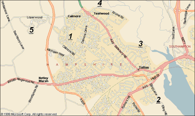
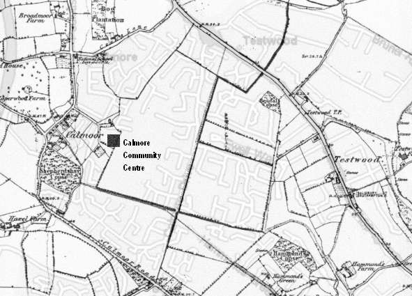
1 Calmore & District Community Association CCA on Map
Managed by Calmore Community Association
Contact Mrs Jean Trinder on (023) 8086 8455 For more Information
Office Hours Mon,Tues,Thurs 9.00am - 12 Midday . Wed 1.00pm - 3.00pm. Fri 9.00am - 11.00am
Aerobics, Brownies, Scouts, Judo, 5-Aside, Kung Fu, Tennis, Keep Fit, Gymnasium, Guides, Bingo, After School Club, Indoor Bowls. Is Just A Small selection of whats avialible
2 The Totton Heritage Museum is at Eling Quay along side the The Tide Mill
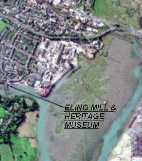
In the Totton & Eling Heritage Centre you can take a walk through time from the Bronze Age to the present day. The Centre also houses the Bronze Age dagger found to the north of the Town when the new Testwood Lakes were being excavated. After your visit why not have a coffee or a light snack in our adjoining Cafe.
The Centre is open in Summer from Wednesday to Sunday 10.00 a.m. to 4.00 p.m. and from November to Easter 10.00 a.m. to 4.00 p.m. on weekends only. Further details can be obtained by telephoning 023 8066 6339
Eling Tide Mill was restored in 1980 as a working Tide Mill Museum. It is one of the few surviving tide mills in the world to harness the power of tide for the regular production of flour. The earliest record of a Mill on Eling causeway is 1086 but the present building dates from the 18th Century.
Eling Tide Mill is not able to operate at high tides for details of milling and opening times you can telephone 023 8086 9575.
Over the bridge and to the left is the entrance to a picnic area Known as Goatee beach showing as a brown area in the picture, If you walk on up the hill to St Marys Church , Parts of which have been here for over 1000 years, and a footpath through the old church yard leads down to meet goatee beach
3 Salmon Leap
The Salmon Leap is located on the Test Way which runs from Totton to Inkpen Beacon making a total walk of 44 miles. In the near future it is hoped to extend the start of the walk to Eling Quay
The River Test is one of the worlds premier fly fishing rivers and fishermen come from all over the world to fish its waters.
Totton Football Ground is on the Bottom Right hand corner .
Testwood School is on the Middle left of the Picture.
The Salmon Leap Pub and entrance to Salmon Leap by the Trees In the Middle right hand side of the Picture
4 Testwood Lakes
The Yellow Patches in the top Middle are the New Testwood Lakes
A Bronze Age dagger and Wooden Jetty was found During the excavation of the New Testwood lakes to the north of Totton. The Dagger and pictures of the excavation can be seen in the the Totton & Eling Heritage Centre at Eling
Totton is in the Centre of the picture the house are mainly greyish with the Industrial estates and Southampton Docks showing up white
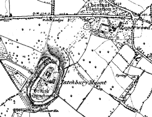
5 Tatchbury Mount Hill Fort
During the Iron Age a hill fort was built at Tatchbury Mount, consisting of extensive earthworks and defences, high banks with wooden fences around the buildings. The earthworks were an a grand scale and extended over 5 acres, you can still see them today.
The Saxons invaded our shore via Southampton Water, a huge battle took place at "Netley Marsh" the area around Tatchbury (which includes Calmore). In excess of 5000 people were slain including the local King whose stronghold was the hill fort.
6 Overlay of 1850 Map Over 2000 Map
Current Archaeology Welcome to the Wonderful World of Archaeology! This is your gateway to the world of British archaeology. These are the home pages of Current Archaeology, Britain's leading archaeological magazine. If you have an interest in anything to do with archaeology, this is the place to find out about digs, discoveries, the latest news, and all about our magazine. Explore the world of archaeology and enjoy yourself!
Current Archaeology Timeline Join us in walking the TimeLine from half a million years ago nearly to the present day. Learn all about the archaeology of Britain from these easy-to-read cyber tours, specially adapted from articles in Current Archaeology. Prehistory 500,000 years ago - Boxgrove man - the oldest man in Britain. 2,500 BC - The Clava Cairns - Neolithic tombs in Northern Scotland . 1300 BC - The Dover Bronze Age boat. 200 BC - Castell Henllys - an Iron Age hillfort in Wales. 100 BC - The Snettisham treasure The Romans AD 43 - The Colchester graves. AD 50 - The story of Roman London. AD 105 - The Vindolanda tablets. AD 200 - A Roman barn at Littlehay. AD 200 - Broch building in the Hebrides AD 300 - Roman Mosaics - highlights of Roman art in Britain. AD 350 - Roman fort at Arbeia The Saxons AD 500 - King Arthur at Tintagel. AD 700 - The Sutton Hoo ship burial. AD 700 - Saxon London founded. AD 800 - Vikings invade the Udal, in the Hebrides. AD 886 - Alfred moves London back to within Roman walls. AD 900 - The origins of the English Village - Shapwick. AD 1000 - Canterbury cathedral re-built The Middle Ages The medieval City: Norwich. Wood Hall: A medieval manor house. The greatest castle - Conwy. A Welsh Castle - Rhosyr Newark Castle Post -medieval Glenochre - a bastle and fermtoun in lowland Scotland. Crossing the Atlantic - Crofters abandon their homes in the Hebrides to find new life in a New World. Witches - How to kill a witch Sundries Feet: how to distinguish Romans and Saxons - by their feet
Britannia's History Department Britannia's History Department has the internet's most comprehensive treatment of Britain's history from the prehistoric era to modern times. Edited by David Nash Ford, the department features timelines, narrative histories, original source documents and important texts, biographies, maps, glossaries, reading lists, informative articles by guest writers, interviews and more.
Maps of Hampshire From Saxtons1575AD to Greenwoods1826AD
Old Hampshire Gazetteer Authored by:- Martin and Jean Norgate: 2001 Place Names & Descriptions
Find A Museum Helps to find any Museum in your area of Interest
British Archaeology British Archaeology Magazine. The CBA works to promote the study and safeguarding of Britain's historic environment, to provide a forum for archaeological opinion, and to improve public interest in, and knowledge of, Britain's past.
Internet Medieval Source Book The Internet Medieval Sourcebook is organized as three main index pages, with a number of supplementary documents. Each individual section is still large. Selected Sources This is an index of selected and excerpted texts for teaching purposes. For teachers who wish to refer students to the Sourcebook, this page is the best starting point.
Old English Pages & Links To Other Sites and Information
Hampshires online Collections Lists Museums & Collections
Internet Archive of Texts and Documents The Internet Archive of Texts and Documents is a creation of faculty and students in the History Department of Hanover College. The principal goal of the Archive is to make primary texts and secondary sources on the internet available to students and faculty for use in history and humanity classes.
Internet Archaeology Magazine The first fully refereed e-journal for archaeology
Medieval Life - The Magazine of the Middle Ages
Welcome to ORB! ORB is an academic site, written and maintained by medieval scholars for the benefit of their fellow instructors and serious students. All articles have been judged by at least two peer reviewers. Authors are held to high standards of accuracy, currency, and relevance to the field of medieval studies.
Anglo-Saxon, Viking, Norman and British Living History. Regia Anglorum was a term used by early English writers to describe the English state. It means 'The Kingdoms of the English'. In a twentieth century context Regia Anglorum is a nationwide society with many independent local groups, from Scotland to the south coast, who all work within a tight set of common sense rules. Regia Anglorum attempts to recreate a cross section of English life around the turn of the first millennium. Our actual self imposed brief is AD950 - 1066, although our events may sometimes be set a few decades either side of these dates. It was a time of great flux and change and, as all our public shows are 'datelined', we can demonstrate the changing fashions of the times. It was a time when Britain was host to many peoples - Anglo-Saxons, Anglo-Danes, Norse, Cymru, Viking raiders and even a number of Norman mercenaries. Welcome to the village of Wichamstow. Explore the fictional pre-Conquest estate of 'Wichamstow', where you can find out more about the life and times of late Viking Age Britain. Eorl's manor of Drengham, Here you will discover more about warfare and the defence of Anglo-Saxon Britain.
Southampton’s archaeological collections have come from a variety of sources. The first public museum in the town was opened in 1912 at Tudor House and contained objects donated to the town by local antiquarians and collectors. These mainly consisted of local finds, including stone age tools, Bronze Age burial urns, a Roman altar to the goddess Ancasta from Clausentum, and medieval pottery, masonry and metalwork. (Roman and prehistoric remains on display at the Hartley University College in 1904. Most of these objects were later donated to Tudor House Museum in 1912.)
The British Museum What can you say "The British Museum"
Medieval English History The aim of this site is to provide historical information about cities and towns in England during the Middle Ages, with particular emphasis on medieval boroughs of East Anglia and on social, political and constitutional history. A selection of primary documents (translated into English) revelant to English urban history is included.
In the Totton & Eling Heritage Centre you can take a walk through time from the Bronze Age to the present day. The Centre also houses the Bronze Age dagger found to the north of the Town when the new Testwood Lakes were being excavated. After your visit why not have a coffee or a light snack in our adjoining Cafe.
The Centre is open in Summer from Wednesday to Sunday 10.00 a.m. to 4.00 p.m. and from November to Easter 10.00 a.m. to 4.00 p.m. on weekends only. Further details can be obtained by telephoning 023 8066 6339
A Local History Study Centre would be far beyond the means of groups and individuals working alone.
So Waterside Heritage was formed and has now taken over Hythe Railway Station and its Surroundings through a 99 year lease from the New Forest District Council. It is constituted as a charitable trust with the following aims to establish and maintain a permanent exhibition and study centre in the Waterside parishes of Fawley, Hythe & Dibden and Marchwood and to preserve, conserve and display as appropriate records, photographs, artefacts and other material relating to the history of the three parishes. To promote the study of local and community history within schools and other venues in the Waterside through the use of local facilities, visits, study modules and other means. To support the publication of books and papers on subjects relating to the heritage of the Waterside.
It is hoped to have a formal opening in January 2002. If you would like to know more about Waterside Heritage or the new Heritage Centre for the Waterside please contact us by E-mail watersideheritage@hants.communigate.co.uk and we will be in touch
The Waterside has two local history groups of long standing: Fawley Historians and Hythe & District Historians who have, over many years, been collecting information, data, memories and photographs on the history and development of the Waterside.
Fawley Historians (formerly Fawley Local History Group) since founded in 1959 have collected information and photographs of the Waterside Parishes. Changes have been recorded where possible, growth of industry for example. Help has been given by members to researchers, students and local schools. Donations and grants have contributed to conservation. For More Information Fawley Historians

The above Pictures taken by Susan Lawrence