The current population is about 30,000 and is situated in the New Forest
District and County of Hampshire. Situated on the River Test, the area has
a long history of shipbuilding but also maintains strong links with the
Forest. Until the 1950's New Forest ponies used to roam freely around the
town.
Totton Rivers are The Test, Blackwater, Bartley Water and the Rum which
is not marked on many maps today, but Rumbridge street.and Rumbridge by
the Rushington roundabout mark its passing.
In 1974 Eling Parish Council became Totton & Eling Town Council due
to the increase in size of Totton town. In 850ad the West Saxon King
Aethelfulf gave land for a burial ground and church at Eling Hill. The
church built on the site in the 9th Century was replaced with a simple
stone church by the Normans and part of this original building can still
be seen today.
Eling was entered in the doomsday book as Edlinges and Totton as
Totintone. And a Mill which is also in the survey still survives today as
the Eling Tide Mill. The History of this area can be followed at the
Totton & Eling Heritage Centre which takes you back to the Bronze Age
when some people lived just north of the town at what is now Testwood
lakes. Could the name Totton have been derived from the landing place
of the Teutons "Cerdic and his son Cynric" to Totintone then
Totton
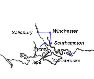 |
Romans In 55 BC Julius Caesar first Attacked
Britain in 54 BC he came and conquered a large area of the country and
sacked St Albans Imposed a tribute and left .Ninety years later in 43 AD
Aulus Plautius a General of The Emperor Claudius Conquered Vectis (Isle
of Wight) and subdued all the land between the Wash and the Southampton
Water There are Remains of a Roman road from Nursling to Stony cross and
roads from Winchester to Southampton and from Lepe to Hythe .It is
thought that the Romans used a ferry from hythe to Southampton and a
ferry from Lepe to the Isle of Wight, Their are remains of roman pottery
works in the New Forest. |
 |
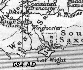
Saxon England The Jutes "a Tuetonic Tribe"
were The First to settle in England so called because they came from
Jutland , Hengist & Horsa were the first in 449 AD, they founded the
Kingdom of Kent. But it was in 495 AD that Cerdic and his son Cynric
landed in southampton water and later went on to Take Winchester and the
Isle of Wight they founded the Kingdom of Wessex. In 508 AD King
Natanlaod was killed by Cerdic at the Battle of Netley (Natanleag) .It
is believed that the battle took place at Netley Marsh .When over 5000
people were Killed. As you can see from the maps the Coast Line was
different in Roman & Saxon Times and erosion has Changed the shape
of the land "see Testwood lakes" .
A.D. 679. The monastery of Coldingiham was destroyed by fire from
heaven.
A.D. 744. The stars went swiftly shooting;
Go to Cerdic and the Cloven Way
and a possible landing at Totton by the Teutons
"Jutes" |
 |
St. Boniface (WINFRID, WYNFRITH).Apostle of Germany, martyred 5 June,
755 (754); He was a native of England, Abbey of Nhutscelle (Nutshalling)
Nursling between Winchester and Southampton. Here, leading an austere
and studious life under Abbot Winbert, In 716 he set out for the mission
in Friesland. In the 12th century Simeon of Durham states that in 764 AD
a number of places were devastated by fire: `The calamity struck
Stretburg [Cirencester?], Winchester, Southampton, the city of
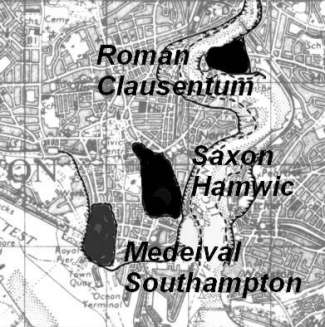
London, the city of York, Doncaster and many other places.We now know
that Southampton , Ipswich and London were all important trading
centres, or wics, from the early 700s. All lay within Mercia, whose
power in the 8th century covered the whole of England south of the
Humber. |
 |
King Canute had his feet washed by the Sea
at southampton, when he proved to his lords that no man Ruled the waves
and such matters should be left for God. In the last 800 years the two
prominences at Lepe have disappeared. The Bays may have Silted up or the
prominences may have washed away or a combination of both but the Maps
of the land between the Isle of Wight and the Mainland changed
considerably
|
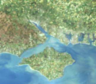 |
An Ariel Photo Shows Hampshire and the Isle of Wight as
it Is Today |
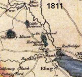 |
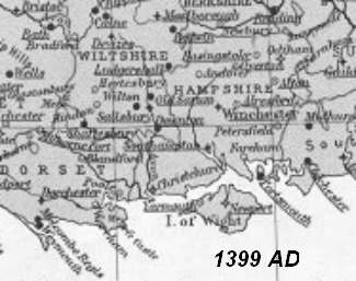
Early Maps were Mainly dependant on who wanted the map
and for what purpose it was intended This 1811 Map is only a small
portion of a Map Picturing the New Forest and so it is not as well
detailed as Most Maps of the Area |
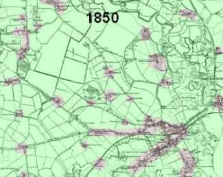 |
One Of the First Maps By the ordinance
Survey, Showing That Actual Buildings Were few and far Between. The Area
is mainly Farms with a few houses at Eling, Old Calmoor & Totton. In
Totton only Commercial Road, Rumbridge Street & Bears Lane had
Groups of houses.
 The Railway line had arrived in 1847 at Totton Via the Southampton to
Dorchester Line. The Locomotive "Frome" was used on The Line
The Railway line had arrived in 1847 at Totton Via the Southampton to
Dorchester Line. The Locomotive "Frome" was used on The Line
|
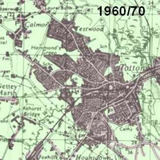 |
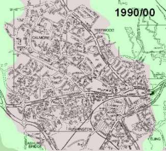
100 Years Later It Is easy to see how
Totton has built up and all the Farms between The Roads are starting to
fill up with Houses. Traffic Had become a nuisance in the Summer as
Bottle necks at The World Stores at The Junction of Salisbury Road With
the Ringwood Road (Now Totton Roundabout) Trying to pass from the New
Forest In The West to Southampton in The East , and for a while Totton
had the Record for the Longest Traffic Jam In The World. |
 |
Totton and Eling is a town of nearly 28,000 population
in the New Forest District and is ideally situated for the New Forest,
the Coast and City Centre Shopping It has a Market every wednesday in
the Town Centre .A Heritage centre , a Working Tidal Mill, Football
Ground, Bowls Centre, And a number of Community Centres And Recreational
Facilities
|
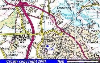
Image produced from the Ordnance Survey
Get-a-map
service. Image reproduced with kind permission of
Ordnance
Survey and Ordnance
Survey of Northern Ireland.
|
The new Testwood Lakes at the top right of picture, where Recent Finds,
include an older river course and a Jetty dated to the Bronze Age , a
Bronze Age dagger was also found. The dagger is now in the Totton
Heritage Centre, At Eling Quay.
If thier was a Jetty here it is possible that thier was a settlement
of some kind here. this could explain why the Roman road took a slight
turn near here to pass by or close to the settlement. It would also mean
that the river was navigable up to this piont and that Totton only came
into being as the river silted up and changed course or became
unpassible to the ships.
The Calmore community Centre is Marked CCA
And Tatchbury hill fort is Just above Tatchbury Manor
Go To Article Wessex News Letter
Bronze age "Jetties" or causeways at testwood lakes |